The collection of ancient maps
Title:
The collection of ancient maps
Producer:
Bernardo Sylvanus
Legend:
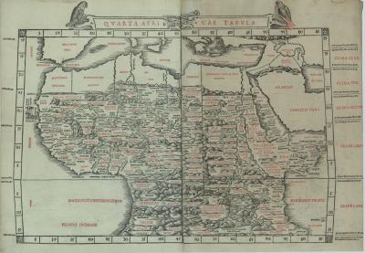
This woodcut is the oldest map in our collection. It is the fourth map of Africa in this reissue of Ptolemy’s ‘Geography’. Countries bordering the Mediterranean are left blank, as they were shown on the preceding three regional maps of this atlas. A particular feature is the printing process in two colours, black first, and red for certain toponyms thereafter.
Place of production:
Italy > Venice
Dimensions:
Map size: 32,4 cm x 49 cm/ Paper size: 38,2 cm x 55 cm
Inventory number:
HO.2006.82.1