The collection of ancient maps
Title:
The collection of ancient maps
Producer:
V. Levasseur
Legend:
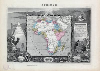
This is one of the last maps of Africa to be set in a frame of picturesque embellishments. These are explained in the text on a plinth to the right of the map. It comes from the ‘Atlas national illustré des 86 départements et des possessions de la France’ and is a steel-engraving, a technique first developed in Britain in 1820.
Place of production:
France > Paris
Dimensions:
Map size: 28,6 cm x 43,4 cm / Paper size: 36,2 cm x 51,2 cm
Inventory number:
HO.1980.54.2-1