The collection of ancient maps
Title:
The collection of ancient maps
Producer:
Guillaume Delisle
Legend:
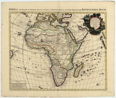
The publication by Guillaume Delisle in 1700 of his map of the African continent constitutes a milestone in the history of cartography of Africa. Stimulated by research undertaken by the French Académie des Sciences the interior of the continent was cleared of all uncertain geographical detail, and his map became a frequently copied model. As for example this edition of ca 1730 by the Dutch firm Covens & Mortier.
Place of production:
the Netherlands > Amsterdam
Dimensions:
Map size: 45,8 cm x 57 cm / Paper size: 56 cm x 66,5 cm
Inventory number:
HO.1973.1.25