Projects
PAStECA
Context: The conversion of natural lands into human-dominated landscapes is a major component of global environmental change. To quantify and understand the complexity of changes and subtle modifications in the environment, an accurate account of past landscape conditions has an important added value. However, sufficiently long, multidecadal records of landscape changes are almost inexistent for the least developed areas of the globe. Objectives: In PAStECA, we make use and valorise the Royal Museum for Central Africa (RMCA)’s unique collection of historical aerial photographs (and other archives) to reveal key information on the transformation of the environment from the mid of the 20th century and its impacts on geo-hydrological hazards and/or risks such as landslides, gully erosion and volcanic eruptions in the western branch of the East African Rift (Burundi, DR Congo, Rwanda). Results: First, we develop custom-made scanning and georeferencing protocols and tools of the photographs and produce digital orthomosaics. Then, machine learning models are developed to extract land use and land cover information from these georeferenced digital products. These photographs dating back to the 1950’s are also used to quantify the impact of human activities on landslide rates. Covering over 60 years, we show that population dynamics, conflicts and deforestation affect geo-hydrological hazards and/or risks in both rural and urban contexts, with differences between the three countries. Conclusion: Through the production of new tools and models we evidence the need to preserve and valorise the aerial photographs and archives conserved at the RMCA to support present-day environmental change studies, especially in Central Africa.
Keywords: historical aerial photographs; land use and land cover change; natural hazard and risk assessment; population dynamics; Africa
Context, Objectives
and Methods
The conversion of natural lands into human-dominated landscapes is a major component of global environmental change. This conversion has been substantial during the past few centuries, but dramatically accelerated during the last decades and is expected to continue in the future. These human-induced transformations of environments can have impacts e. g. on biodiversity, climate and land surface feedbacks, soil degradation and ecosystem services. Land use and land cover change (LULC), such as deforestation, construction of roads and mining activities, can also impact geo-hydrological hazards such as landslides, (flash)-floods and gully erosion; increasing their frequency and/or intensity, and changing their spatial distribution. Furthermore, unsustainable economic development, growing energy use, and uncontrolled and informal rapid urbanisation also contribute to increase risks.
In countries of the Global South, high population densities are common in urban and peri-urban regions as well as in the populated rural areas. These populations are often on the rise (exhibiting above-average growth patterns) and combined with high societal vulnerability. As a result, uncontrolled and informal urbanisation commonly occurs, regardless of environmental constraints. The rapid growth of informal settlements, often located in areas unsuitable for construction, without basic services, consequently increases the vulnerability of large populations to natural hazards. It is therefore not surprising that hazard risks are increasingly common threats for citizens in these regions of the Global South. In the future, changes in LULC, including deforestation, irrigation development and urban sprawl, will alter many drivers of geo-hydrological hazards and, as such, increase their impacts. In addition, climate change has also the potential to alter the drivers of these hazards by increasing extreme weather events such as cyclones, storms, and floods. Despite these trends, geo-hydrological hazards and risks are still not properly documented and addressed, nor analyzed in a context-specific approach. Yet, the need to better understand the past and current events in order to properly assess potential future occurrences and exposure is crucial.
To quantify and understand the complexity of changes and subtle modifications in the environment, an accurate account of past landscape conditions and recent changes over a multidecadal time scale has an important added value. However, sufficiently long, multidecadal records of LULC changes are almost inexistent for the least developed areas of the globe. This important lack is not easy to fill: global and regional LULC assessments derived from the first satellite data from the 70s and 80s offer a spatial resolution that is often too coarse for this purpose and the very high resolution satellite data became available only at the end of the 90s at best. The use of historical black and white aerial photographs offers the possibility of studying a longer time frame. Such photos show excellent spatial details that make them appropriate for studying, for instance, topics as different as forest transition, landslide dynamics, soil erosion and urban sprawl.
Although this added value of historical aerial photographs is evident, especially in Africa where data availability is scarce, their use is still too often limited by quality or availability of ancillary data. The unique collection of historical aerial photographs (> 300,000 photographs) that are conserved at the RMCA and that cover the entire DR Congo, Burundi and Rwanda have the potential to fill this gap. These are an important but hitherto poorly exploited archive from the mid of the 20th century. Additionally to these photographs, archives such as relevant maps also available at RMCA (rural cadastre, urban cadastre, etc.) can provide supplementary information on historical LULC.
The general objective of the PAStECA project is to make use and valorise the aerial photographs and archives conserved at the RMCA to reveal key information on the transformation of the environment and its impacts on geo-hydrological hazards and/or risks such as landslides, gully erosion and volcanic eruptions in target tropical environments of Central Africa. The first specific objective is to produce geolocalised digital products of the historical photographs and archives that can be used for LULC studies in general. The second specific objective of this proposal is to explore the causes, impacts, scales and trends of the LULC and its changes in the context of geo-hydrological hazards and risks with the help of these digital products. The third specific objective is dedicated to improve accessibility of digital products related to historical photographs, archives and LULC changes to foster their exploitation.
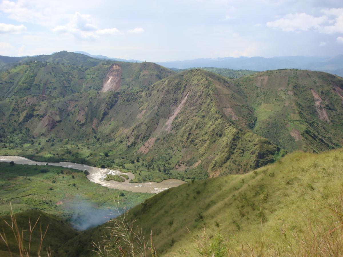
The project deals with land occupation and demography, land degradation, geomorphology, geo-hydrological hazards and risks, and geomatics and remote sensing. In order to carry out the project in the most efficient way, research is focused on a well-defined study area located in the tropical mountain environments of the western branch of the East African Rift. The region of interest extends from the North Tanganyika rift zone in the south to the Virunga Volcanic Province in the north. Its LULC evolution is very interesting to study because of the combination of various natural and human characteristics (i.e. high population densities and vulnerability, border between three countries, diversity in landscape, recent land degradation, various conflicts, urban sprawl, numerous occurrences of landslides, very active volcanoes, etc.).
Results and recommendations
With respect to the archive data and geolocation: The historical aerial photographs conserved at the RMCA correspond to paper reproductions of aerial surveys performed during the 1940′s and 1950′s by local colonial, Belgian and French geographical institutes. Overall, the quality of the paper photos is usually relatively poor, depending on the dataset and the photo band. Therefore, we first, we developed custom-made scanning and georeferencing protocols and tools of the photographs. This allowed to scan more than 8000 photographs. From these photographs, we produced a regional orthomosaic covering more than 20,000 km² and well as specific orthomosaics for the three cities of Bujumbura in Burundi, Bukavu in DRC and Goma-Gisenyi at the border between DRC and Rwanda. In addition to the photograph processing, thousands of maps and other archives where scanned and made accessible via the Geocatalogue.
Then, machine learning models were developed to extract land use and land cover information from these georeferenced digital products. At the regional level, we extracted the forest. It shows that in the 1950’s large portions of the region of interest were already deforested. Comparing that to satellite data, we were able to reconstruct the forest cover dynamics over a period six decades. At the city level, we extracted information on vegetation and the built environment. We show that over six decades urban areas have grown in an exponential manner.
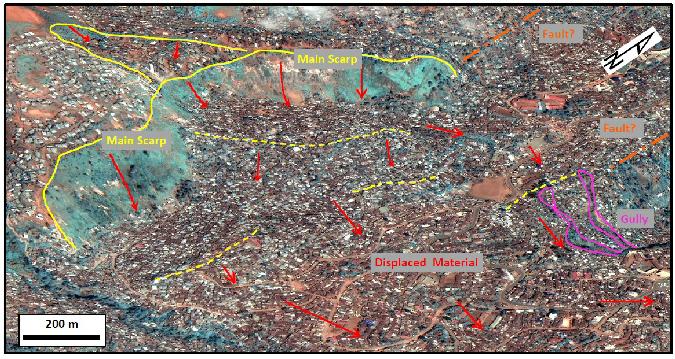
At the regional level, we used the photographs to quantify the impacts of human activities on landslide rates and risks. Paying a specific attention to the geodynamics of the rift and the geomorphological contrasts of the hillslopes and the lithologies, and developing specific models of landslides spatio-temporal occurrence and deforestation, we show that the current landslide risk in the eastern DRC is twice as high as in neighbouring Rwanda and Burundi. Congolese households, on average, populate more hazardous terrain, probably as a result of conflicts and economic pull factors such as mining. Moreover, the recent large-scale deforestation of primary rainforest in the DRC has considerably exacerbated the landslide risk. Although the risk has increased due to human activities, we show that the latter have somehow a lower impact on the landside rates.
At the level of the cities, we show, from a combination of the historical information from photographs and archives, and key knowledge from more than 150 local stakeholders, that demographic dynamics and social triggers such as violent conflicts and wars were positively related to urban expansion. Second, as population pressure increased, constraining effects of natural environment such as relief and risks of natural hazards weakened, leading to urban development in less suitable areas.
The results of the PAStECA project were published in more than 10 scientific publications in peer-reviewed international journals and two PhD theses. PAStECA also produced digital products, tools, models and datasets that are relevant to valorize historical photographs and archives as well as to study geo-hydrological hazards and risks, and more generally the changing environment and its impacts. In addition, project outputs were disseminated, via, for example, the support of a permanent exhibition in DRC that aims to educate and raise awareness on the issues of natural hazard risks.
The need to preserve and valorise a unique collection: PAStECA demonstrated that with rather limited means the preservation and the valorisation of historical aerial photographs is possible. However, PAStECA also shows that many of these photographs are deteriorating, therefore highlighting the urgent need to upscale such a work at the level the whole collection.
Keywords: historical aerial photographs; land use and land cover change; natural hazard and risk assessment; population dynamics; Africa.
Principal investigator:
Dates:
2017 2022Museum staff:
External collaborators:
• Arthur DEPICKER, KU Leuven
• Liesbet JACOBS, KU Leuven
• Anton Van ROMPAEY (WP leader), KU Leuven
• Gerard GOVERS (WP leader), KU Leuven
• Eléonore WOLFF (WP leader), ULB
• Taïs GRIPPA, ULB
• Moritz LENNERT, ULB
• Nicholus ODHIMABO MBOGA, ULB
• Sabine VANHUYSSE, ULB