Geodynamics and mineral resources
The service carries out fundamental and applied research on geology, geodynamic processes, and natural resources (essentially mineral) in Central Africa and neighboring regions.
We study the main lithological units (cratons, mobile belts, sedimentary terrains) to understand their genesis and evolution over geological time (geodynamics), with a particular focus on the formation of ore deposits.
Our work also examines the interactions between geology and human societies. Geological resources not only include minerals essential for development but may also encompass remarkable natural sites worthy of preservation. Underground cavities can hold valuable records of paleoclimates and evidence of their use by humans, fauna, and flora over time. Additionally, we study the social and environmental impacts of mining activities on local populations.
We pursue a knowledge and skill transfer policy for universities and governmental services in geology and mining, particularly in the D.R. Congo, Republic of the Congo, Burundi, and Rwanda.
- Staff
-
Scientific personnel
- Camille François, Head of service
- Imen Arfaoui, Geologist
Ressources minérales : exploration et valorisation - Anouk Borst, Geologist
Magmatisme alcalin et ressources minérales associées (terres rares) - Thierry De Putter, Geologist
Geology and metallogeny of supergene mineral deposits, contribution of mineral resources to development - Lilian Eyletters, Archivist
- Sage KEBI-TSOUMOU, Geologist
- Amaury Ketele, Archivist
- Martin Klassen, Archivist
- Florias Mees, Geologist
Paleoenvironments, soil science, mineralogy - Mylène Mombru, Geologist
- Bossissi Nkuba, Biologist
- Mathias Potvin, Geologist
- Timo Van Havere, Archivist
Projet PanafGeo+ - Sachinthani WEERANAYAKE, Remote Sensing Geologist
Volunteers
- Daniel Baudet, Geologist
Lithostratigraphie et géodynamique des chaînes protérozoïques (Kibarien, Ouest-Congolien) - Stijn DEWAELE, Geologist
Geodynamic context and metallogeny of mineral resources in Central African pre-Cambrian mobile belts - Eric Hanssen, Geologist
Métallogénie et prospection des ressources minérales - Gérard Nimpagaritse, Geologist
Géologie régionale et géodynamique du Kibarien - Louis-Paul Taverne
- Théodore Trefon, Expert in governance and natural resources
environmental governance and development in DRC
Emeritus researchers
- Luc Tack, Geologist
Géodynamique générale y compris ressources naturelles; Précambrien et formations de surface; Afrique (Centrale); supercontinents; compilations cartographiques
- Research
-
Our study areas are primarily located in the Democratic Republic of the Congo (Kongo Central, Mayombe, Kasai, Katanga, Kivu), the Republic of the Congo and Burundi and Rwanda (Great Lakes region).
Cratons and mobile belts
Our research aims to increase knowledge about cratons (regions stabilized for more than 500 million years), particularly in Central Africa, and the surrounding orogens (mountain belts). We are specifically studying the evolution of geodynamics during the Precambrian (a geological period spanning from 4.6 billion years ago to around 500 million years ago) and the development of plate tectonics on Earth during this period, with a focus on metamorphic rocks. To achieve this, we use petrology, thermobarometry, structural, geochemistry, and geochronology. We are also interested in the links between geodynamics and the origins/remobilizations of mineral resources associated with cratons and orogens.
Mineral resources
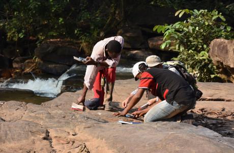
We study the geological formation and distribution of African mineral resources and carry out fundamental geological research required to inform models for sustainable exploration and exploitation. We have also participated in mineral traceability efforts, and study the socio-economic and environmental implications of mining activities on the local population and society.
Special attention is paid to the artisanal mining sector in the Great Lakes region, the source of half of the world’s supply of tantalum (used in the mini-capacitors of mobile phones) and a fraction (a few %) of the world’s gold. The region is a major frontier for exploration and exploitation of strategic critical raw materials such as lithium and copper, which recently led to EU strategic partnership agreements with the DRC and Rwanda.
In a broader sense, the service also studies environmental governance in the DRC, that is, the body of regulation related to the management of the natural environment: agriculture, forestry, mines and oil.
Secondary ore deposits
We study the genesis of secondary, oxidized ore deposits, brought into contact with the atmosphere during the Cenozoic uplift of the basin’s southern and eastern margins, in connection with the opening of the Great Rift Valley’s western branch, some thirty million years ago.
Some of these deposits are world-class ones (notably copper and cobalt in Katanga). The impact of mining activity on public health in the province of Katanga or the Kivu region is also studied by the service.
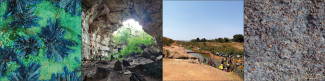
Studies of karstic zones
We study rock formations that develop underground cavities. The cavities have accumulated and preserved over time large quantities of geological information that is more difficult to observe at the surface. Our studies provide us with a better understanding of the processes behind the development of cavities, as well as the climates during their evolution.
The mapping of these cavities that we to locate areas at risk of collapse, but also to know underground rivers, which are local water resources, or even regional water resources, and to identify the risks of contamination.
The caves studied are special biotopes biotopes containing numerous endemic species in need of protection. They are also often places of refuge or worship for populations throughout time. Archaeological discoveries by our teams are commonplace.
Karst areas are often listed as remarkable sites as remarkable sites in the world and they can thus constitute sustainable resources through tourism. Our works is helping to document these remarkable sites.
Social and environmental impacts of mining activities on local populations
The overarching aim of this research project is to understand the distribution of water resources, the dynamics of water pollution in the Katanga and the uneven access to clean water, in order to propose policies that can ensure a fair, safe and sufficient access to clean water for communities in cities and mining areas. Three specific objectives will be pursued: 1) assessing the availability of water resources and natural risks due to the local geology and presence of (potentially toxic) metals in the soil and underground, 2) assessing the anthropogenic risks due to mining activities and human settlements. These risks will include pollution of water resources, biodiversity loss and risks for human communities, and 3) understanding the political ecology of water governance in this region. The project is justified by the strategic importance of cobalt in the green energy transition, as well as its negative externalities in terms of water pollution and uneven access to water resources for local populations.
Win-Tensor program for tectonic stress reconstruction
The Win-Tensor program is an interactive software for tectonic stress determination from geological fault-slip and earthquake focal mechanisms data in structural geology, neotectonic and seismotectonic investigations. Besides its capacities for data storage and management, it allows reconstructing the four parameters of the reduced paleostress - or stress - tensor (orientation of the three principal stress axes and the shape ratio of the stress ellipsoid) using a refined Right Dihedron method and an iterative Rotational Optimisation procedure. It allows kinematic separation of fault-slip and focal mechanism data together with progressive stress tensor optimisation. Emphasis is given to user interactivity for controlled data acquisition, data selection and rotation, tensor estimation and optimisation, graphical representation and quality ranking according to the World Stress Map data base. This program is available freely for academic and scientific use.
Web site: Win-Tensor.