African Geographic Pictures Collection
Search |
About the collection |
Practical guide |
Contact
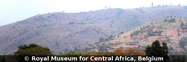
| Image number: | 2131 |
| Feature : | landslide |
| Grouping : | mass movements |
| Discipline : | geomorphology |
| Year : | 2007 |
| Locality : | Mulongwe - Kalimabenge |
| Country : | D.R.Congo |
| Region - tribe : | Uvira |
| Physiographic region : | Rift-Tanganyika |
| Notice : | The Mitumba Range between Mulongwe and Kalimabenge is affected by huge active landsliding. On the hillside in the middle, recent scars of a huge soilslip are visible. On the right hill, the township of Uvira is expanding. |
| Reference : | Moeyersons, Jan, 2007 Image 2131. In : Moeyersons, Jan : "African Geographic Pictures", http://www.africamuseum.be/nl/research/collections_libraries/earth_sciences/collections/geopic" |