African Geographic Pictures Collection
Search |
About the collection |
Practical guide |
Contact
| Image number: | 2258 |
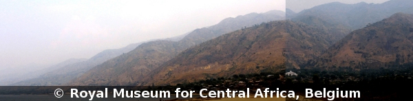
| Feature : | fault step |
| Grouping : | tectonics |
| Discipline : | geology |
| Year : | 2007 |
| Locality : | Uvira - Kalimabenge - port |
| Country : | D.R.Congo |
| Region - tribe : | Mitumba Range |
| Physiographic region : | Rift-Tanganyika |
| Notice : | Fault facets. The landslide of the port is visible on the middle facet. The facets dip at about 40° towards the Lake Tanganyika. The main equilibrium slope for landslides in the area is in the range 25° - 30°. |
| Reference : | Moeyersons, Jan, 2007 Image 2258. In : Moeyersons, Jan : "African Geographic Pictures", http://www.africamuseum.be/nl/research/collections_libraries/earth_sciences/collections/geopic" |